LandGlide: GPS Property Finder
Advertisement
Overview
LandGlide is a powerful GPS property finder app that allows users to easily explore land ownership information and boundaries with just a few taps. With detailed maps and property data, users can quickly identify properties and access relevant information on the go.
Get the app
All link sources on this site are jumped to App Store, Google Play and other official platforms. No virus, no malware.
Select a PlatformAdvertisement
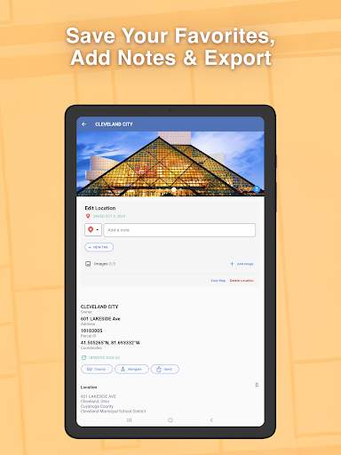
Screenshots


Description
LandGlide is a cutting-edge GPS property finder app that provides users with easy access to detailed property information right at their fingertips. Whether you are a real estate professional, a property investor, or simply someone interested in exploring property data, LandGlide offers a user-friendly platform to help you navigate through vast amounts of property information with ease.
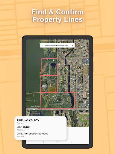
One of the key features of LandGlide is its intuitive and interactive map interface, which allows users to easily search for properties by simply tapping on the map. By using GPS technology, LandGlide accurately pinpoints your current location and displays property boundaries, parcel lines, owner information, and other relevant data for any property you are interested in. This feature is particularly useful for real estate agents who need quick access to property information while on the go, enabling them to efficiently conduct property research and provide valuable insights to their clients.
In addition to its mapping capabilities, LandGlide also offers a comprehensive database of property information sourced from public records, including property ownership details, tax assessments, property boundaries, and sales history. Users can easily access this information by searching for a specific address or parcel number, allowing them to gather valuable insights into a property's history and ownership.
Another standout feature of LandGlide is its ability to provide users with customizable map layers that can be toggled on or off based on their preferences. Whether you are interested in viewing flood zones, zoning information, or topographic data, LandGlide allows you to tailor the map display to suit your specific needs. This level of customization ensures that users can focus on the property information that is most relevant to them, enhancing their overall user experience.
Moreover, LandGlide offers seamless integration with other mapping tools and applications, allowing users to easily share property information with colleagues, clients, or other stakeholders. This integration streamlines the process of collaborating on property research and analysis, making it easier for users to work together and make informed decisions.
Overall, LandGlide is a powerful and versatile GPS property finder app that is designed to simplify the process of accessing property information and conducting property research. Whether you are a real estate professional looking to stay ahead of the competition or a property enthusiast interested in exploring property data, LandGlide provides a comprehensive platform to meet your needs. With its user-friendly interface, detailed property information, and customizable map layers, LandGlide is a valuable tool for anyone involved in the world of real estate.
Advertisement
System Compatibility
Make sure your system meets the requirements for using LandGlide.
Compatible with iOS and Android devices.
May not work on older versions of devices.
Performance may vary based on device specifications.
Permission Access
Understand the permissions LandGlide requires for optimal functionality.
Requires access to location, camera, and storage for map and property data.
Location access is needed for GPS mapping, camera access for augmented reality, and storage for saving preferences.
Update Content
Stay informed about the latest updates and enhancements to LandGlide.
Added new map layers for better property visualization, improved search functionality with faster results, and enhanced user interface for better navigation.
FAQ
How does LandGlide help me find properties?
LandGlide uses GPS technology to show you parcels of land on a map.
Can I search for specific properties on LandGlide?
Yes, you can search for specific properties by address or parcel number on LandGlide.
Is LandGlide available for all regions?
LandGlide covers most regions in the United States, but may not be available everywhere.
Can I save properties I find on LandGlide?
Yes, you can save properties to your favorites list on LandGlide for easy access.
Does LandGlide provide property ownership information?
Yes, LandGlide provides property ownership details for parcels of land on the map.